Onehunga Wharf
01 July 2018 - TBC
- Onehunga
- In Progress
- Urban regeneration
Creating public spaces and connections at Onehunga Wharf
We are working to open up Onehunga Wharf to the public, collaborating with the community over that time to understand what is desired for the area long-term.

The Onehunga Wharf was transferred from Ports of Auckland Limited (POAL) to Auckland Council in 2018, with a view to open it up over time for public use, as well as investigating its potential for development.
The wharf is currently not open to the public as large parts of the land are commercially leased areas with large machinery operating.
Parts of the wharf land are subject to the NZ Transport Authority Waka Kotahi (NZTA) project, the East West Link. The project has been identified as a Road of National Significance with an announcement on their plans and timings made in October 2025. The next 12-months will see NZTA work to develop, refine and route protect the preferred (revised) corridor, whilst looking at ways to stage sections of the project with a focus on Stage 1, Galway Link. NZTA will be engaging with local stakeholders, landowners and businesses in the coming weeks and months, and undertaking ground and environmental investigations to help inform this work.
The Auckland Urban Development Office have been investigating several projects to enable public access to the area. These plans are about reconnecting people with the area and creating better connections between the wharf and the Onehunga town centre. These projects seek to improve public access, provide environmental restoration, and create a new public realm and activation space at the Onehunga Wharf; whilst providing opportunity for the community to feedback on what is desired for the area long-term.
Now that we have confirmation of NZTA's plans and timings for the East West Link, we are working through our plans for the wharf area and will update the community with details as soon as we can.

Project Objectives
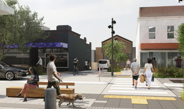
Public space and activation
Create a welcoming public area at the Onehunga Wharf that also connects people to the space through the stories of mana whenua, the coastline and Manukau Harbour. Test how the area can facilitate activations, play, and community activities.
Connectivity
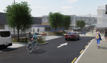
Create better connections that allow people to easily and safely move through the area. Prioritise improved walking and cycling connections to the wharf and along the coastline.
Coastal regeneration
Implement a mātauranga based restoration project - to restore, protect and enhance current (and past) terrestrial and marine habitats and their ecological connections to improve the mauri of Manukau Harbour. Provide greater resilience and protection from storms, sea level rise and climate change.

Project Areas
We have been looking at implementing a few projects across different areas at the wharf:
Area A
A corridor along the north that is planned to be used for a walking and cycling connection project that connects the wharf to the Ngā Hau Māngere bridge and Onehunga Town Centre.
Area B
This section of land at the port’s western and coastal edge is the primary focus of a coastal restoration and public activation area.
Area C
This is the commercially leased area of the wharf with several businesses operating.
East West Link
The East West Link project area is marked up with its Notice of Requirement/former designation area and extent. The designation shows the area that would be used to construct the project and the extent is the area where the finished project will end.
Q&A
Why is it taking so long for anything to happen at the wharf?
The wharf came under Council ownership, after being transferred from Ports of Auckland, in 2018. Auckland Council wanted to retain the wharf within the council group and open it up over time for public use, as well as investigating mixed-use development. Since then, work has been underway on the planning for the area both short-term and long-term.
However, parts of the wharf are subject to the NZTA project the East West Link. Until confirmation of this project and its area of impact were clear, plans for the wharf have been difficult to be completed and able to be implemented.
In the meantime, we have continued to operate the wharf site on a commercial basis on behalf of Auckland Council, providing value for the city and the regional economy. We have continued to investigate the ongoing cost of the protection of character and amenity at the site, to ensure appropriate value is achieved for tenants and Auckland Council.
When will it be announced whether the East West Link is going to happen?
There have been a variety of announcements, updates, and changes to the East West Link project over the past 10 years. The project has most recently been identified in the draft Government Policy Statement on land transport (GPS 2024) as a Road of National Significance with an announcement on plans and timings in October 2025.
The next 12-months will see NZTA work to develop, refine and route protect the preferred (revised) corridor, whilst looking at ways to stage sections of the project with a focus on Stage 1, Galway Link.
NZTA will be engaging with local stakeholders, landowners and businesses in the coming weeks and months, and undertaking ground and environmental investigations to help inform this work.
For more information and updates, please refer to the NZTA project page.
www.nzta.govt.nz/projects/east-west-link
Who currently has access to the wharf?
The wharf is currently a commercially leased area and is not open to the public. It is used by several commercial clients, fishing boats, and the coastguard.
Why can’t the public access the wharf area now?
The wharf is the site of commercially leased properties, which sees large machinery operating, with extensive health and safety requirements for anyone on site. Auckland Urban Development Office is working to open parts of the wharf in stages over an extended period, collaborating with mana whenua and the community to understand what is desired for the area long term.
Is there any reclamation planned for the wharf area?
Reclamation of land is not currently being considered. Reclamation of any area would need to be considered carefully and engagement required with Mana Whenua Iwi o Tāmaki Makaurau and relevant stakeholders as part of the consideration of the long-term redevelopment of the wharf area.
Why did Council apply for a Coastal Consent for the wharf for another 35-years?
The recent Coastal consent application, that was publicly notified, is not a lease extension and does not signal that the wharf will continue to be a commercial wharf for the next 35-years. The coastal permit that was applied for allows for activities to occur in the water space next to the wharf, with the current consent allowing this expiring in 2026. Without this coastal consent any activities or operations in the water space area next to the wharf are no longer permitted. This consent does not hinder or preclude future public access to the wharf area. This consent allows for activities to occur in the water space.
Other projects in Onehunga

- Onehunga
- In Progress
- Urban regeneration
- Development
Te Pūmanawa o Onehunga
07/04/2025 - 03/04/2025
- Onehunga
- In Progress
Waiapu Precinct
12/02/2024

- Onehunga
- In Progress
Church Street improvements
19/01/2024
- Onehunga
- In Progress
Paynes Lane Improvements
01/01/2022